

Birding Escapes: Pawnee National Grasslands, Colorado
by Bobby Harrison
January 1, 2010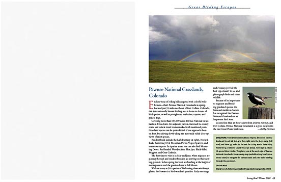
More From Living Bird
 Living Bird Winter 2010—Table of Contents
 Living Bird Magazine—Latest Issue
 Living Bird Magazine Archives

Endless vistas of rolling hills carpeted with colorful wildflowers— that’s Pawnee National Grasslands in spring. Located just 35 miles northeast of Fort Collins, Colorado, this internationally known birding area is home to dozens of bird species, as well as pronghorns, mule deer, coyotes, and prairie dogs.
Covering more than 193,000 acres, Pawnee National Grasslands is divided into two adjacent parcels, traversed via county roads and vehicle travel routes marked with numbered posts. Grassland species can be quite skittish if you approach them on foot, but driving slowly along the auto trails yields close-up views of most species.
Resident birds include the Lark Bunting (at right), Horned Lark, Burrowing Owl, Mountain Plover, Vesper Sparrow, and numerous raptors. In riparian areas, you can also find Mourning Doves, Red-headed Woodpeckers, Blue Jays, Black-billed Magpies, and Gray Catbirds.
The best time to visit is in May and June, when migrants are passing through and resident breeders are arriving on their nesting grounds. In late spring the birds are bustling at the height of nesting season and the grasslands are in full bloom.
With as many as 301 species of birds using these windswept plains, the Pawnee is a bird-watcher’s paradise. Early mornings and evenings provide the best opportunity to see and photograph birds and other wildlife.
Because of its importance to migrants and breeding grassland species, the National Audubon Society has recognized the Pawnee National Grasslands as an Important Bird Area.
Located less than an hour’s drive from Denver, Greeley, and Fort Collins, Pawnee National Grasslands is a great escape into the vast Great Plains wilderness.
Directions
From Denver International Airport, drive west on Pena Boulevard to exit 6B East-470. Turn right onto the E-470 ramp (toll road) and drive 3.5 miles to the exit for US-85 North. Take US-85 North for 52.6 miles to County Road-90 (CR90). Turn right (East) on CR-90 and drive 8 miles. This places you at the west edge of Pawnee National Grasslands. Use a county map (available at any local convenience store) to navigate the various roads and auto trails winding through the grasslands.
On the Web: Pawnee National Grasslands, Arapaho and Roosevelt National Forests

All About Birds
is a free resource
Available for everyone,
funded by donors like you
American Kestrel by Blair Dudeck / Macaulay Library