

9 Ways People Have Used eBird Data to Make Conservation Happen
By Victoria Campbell
June 29, 2016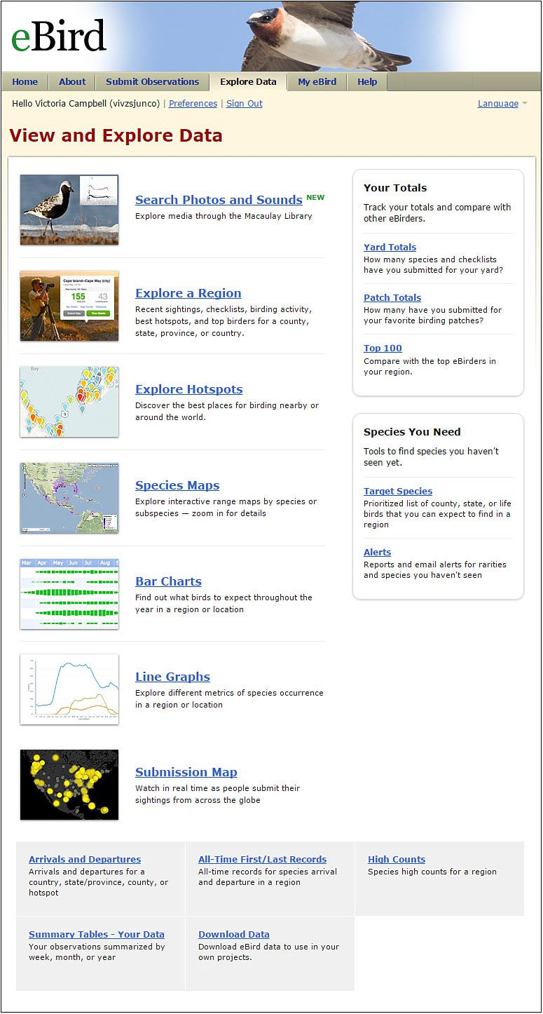

Save an endangered species, protect eagles from wind turbines, expand protected lands, or even outlaw drones from bothering wildlife. It doesn’t matter who you are, you can help make conservation actions happen—as long as you have ready access to data.
That’s what researchers discovered when they investigated how people are using data from the Cornell Lab’s eBird project to achieve conservation goals. It turns out that when citizen science projects make their data publicly available, as eBird does, they help bridge the so-called “knowledge-to-action gap” that can plague conservation.
Since 2002, eBird has received more than 300 million observations—70 million of those in 2015 alone. At the eBird website, you can view that data as maps or other visualizations and browse by species, location, and date. For more formal analyses, the entire data set is freely available to download, and more than 2,100 people from all over the world have downloaded it.
A research team from the Cornell Lab sent out surveys to users of the full data set to learn how people used the data. They documented 159 examples of people or groups that used eBird for conservation action. A third of all responses were from private citizens rather than academics, indicating that citizen science projects can extend a person’s role from data collector to data user. The team published their findings in the journal Biological Conservation.
According to their results, it turns out that people are using eBird data in various ways; from researching and monitoring conservation areas and species, to conservation planning, habitat and species management and protection, and even in making policy decisions and laws. And they’re using it all over the world. We dove into the paper and pulled out these top 9 examples of how and where the data were used to create real on-the-ground conservation action:
Related Stories

- Helped develop the IUCN Red List of Chile’s threatened birds. When there is little information on a species, little can be done to help protect it. The Chilean Birding Network used eBird to get occurrence information on seven data-deficient bird species, allowing their conservation status to be assessed for the IUCN Red List.
- Instrumental in listing the rufa Red Knot as a threatened subspecies, U.S. The rufa subspecies of the Red Knot migrates up to 20,000 miles a year between Tierra del Fuego and the Arctic, stopping in places like Delaware Bay to feast on abundant horseshoe crab eggs. When increased harvests of horseshoe crabs caused rufa Red Knot populations to crash in the 2000s, eBird reports helped fill gaps in data about the bird’s numbers all across its migratory route. The U.S. Fish and Wildlife Service decided to list the rufa Red Knot as Threatened under the Endangered Species Act in 2013.
- Helped determine species distributions for poorly known, rare species, Philippines. Three species of ground-warblers—one only just discovered in 2013—are so secretive that they’re only known from a few dozen locations. A group of researchers used eBird and museum data to model the ranges of the species. The results highlighted the need for land protection in currently unprotected parts of the country.
- Expanded a Ramsar site in the Fraser River Delta, British Columbia, Canada. The Ramsar Convention, also known as the Convention on Wetlands, helps secure protection for wetlands deemed internationally important. A review of the Alaksen Ramsar site in British Columbia used eBird data on species abundance, finding it is a major wintering and migratory stopover area for gulls, seaducks, and shorebirds. As a result, the area was designated as a Wetland of International Importance, and increased 40-fold in size to become the 51,000-acre Fraser River Delta Ramsar site.
- Helped list the Pacific subspecies of Western Screech-Owl as threatened, Canada. The Committee on the Status of Endangered Wildlife in Canada used eBird data to determine that the kennecottii Western Screech-Owl subspecies in Canada is largely confined to Vancouver Island and the south coast of British Columbia. As a check, they also examined eBird data on Barred Owls, and found these owls are reported across the region. The agency concluded that the absence of screech-owl data was not due to the lack of observations, but rather the lack of birds. The committee listed the coastal subspecies of Western Screech-Owl as threatened in 2012.
- Aided local environmental planning, U.S. Agencies and public groups have used eBird data at local scales for projects including siting communication towers away from sensitive species and migration routes; planning wind farms in Tennessee to avoid potential conflicts with eagles; helping to safeguard power poles in Colorado to reduce electrocution risk for raptors; and adjusting mowing practices to aid grassland birds in New York.
- Identified sites with high conservation value, Wellington, New Zealand. Local ornithologists used 100,000 eBird records from around Wellington to identify 52 sites with high value for resident and migrant birds. The large amount of data allowed them to set criteria and objectively assess which sites had significant conservation value, and the results were incorporated in the region’s Natural Resources Plan.
- Helped plan waterfowl nest box placement in British Columbia, Canada. The Rocky Mountain Naturalists club used eBird to help improve nesting success of cavity-nesting waterfowl. By learning what duck species were present in certain areas, the club was able to place nest boxes for appropriate species in the birds’ preferred locations.
- Helped pass a law to limit drone flights in Florida state parks, U.S. eBirders observed that drones flying in Tomoka State Park disturbed birds such as rails, causing them to fall silent and in some cases remain so for several days. In 2015, partially in response to these findings, the use of drones was prohibited in all Florida state parks.
All About Birds
is a free resource
Available for everyone,
funded by donors like you
American Kestrel by Blair Dudeck / Macaulay Library