

Unsafe Haven? Teshekpuk Lake, Alaska
By Lisa Drew January 15, 2008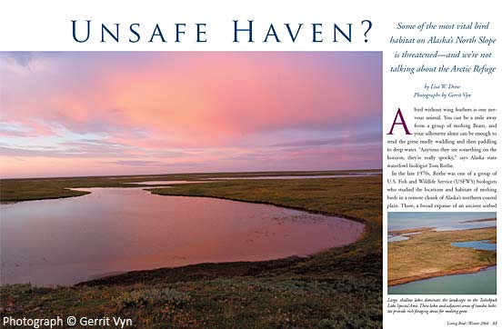
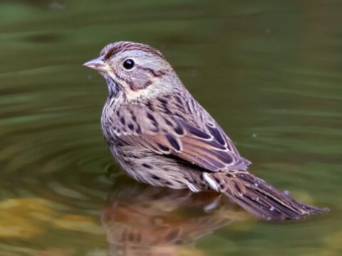
A bird without wing feathers is one nervous animal. You can be a mile away from a group of molting Brant, and your silhouette alone can be enough to send the geese madly waddling and then paddling to deep water. “Anytime they see something on the horizon, they’re really spooky,” says Alaska state waterfowl biologist Tom Rothe.


In the late 1970s, Rothe was one of a group of U.S. Fish and Wildlife Service (USFWS) biologists who studied the locations and habitats of molting birds in a remote chunk of Alaska’s northern coastal plain. There, a broad expanse of an ancient seabed juts out into the Beaufort Sea, with enormous Teshekpuk Lake bordering much of its southern edge, so the land to the northeast seems almost like an island. Over time, a phenomenon called thermokarsting—in which the melting of ice-rich soil creates depressions in the ground surface—has carved more than 150 basins containing shallow lakes. Most have partially drained, and the fine marine sediment has fostered wide marshy meadows around the lakes’ edges that include two goose favorites: Hoppner’s sedge and creeping alkaligrass. Both plants thrive in tidal marshes or areas were saltwater occasionally intrudes.
For waterfowl focused on gobbling up nourishment to regrow feathers and fuel upcoming fall migrations, the setting could not be more ideal. They never have to venture far from water to find more food, and the region is so removed from human activity that the birds rarely make calorie- and time-consuming dashes to the water except when threatened by predators. When they do, as Rothe puts it, “the lakes physically are big enough so the birds can swim off and bob around safely.”
Those 1970s studies were prompted by some experimental drilling in the region by the U. S. government, and the biologists concluded that some portions of the Teshekpuk Lake region should be off limits to oil and gas leasing because of the skittishness of molting geese. At the time, the point turned out to be moot: serious oil extraction would not be feasible there anyway until a quarter of a century later, as an expanding network of pipelines got closer and closer. Perhaps you’re guessing that the area in question is part of the Arctic National Wildlife Refuge (ANWR). That would make sense. After all, we’ve all been told for decades that the most important wildlife habitat on Alaska’s northern coastal plain is in the refuge.
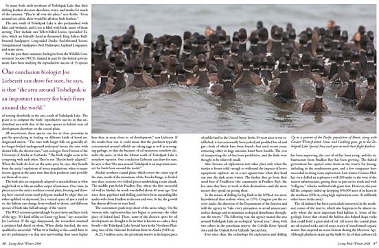
Birds, however, tell a different story. The area around Teshekpuk Lake, which is roughly 175 miles west of the arctic refuge, draws hundreds of thousands of migratory birds—representing dozens of species—every summer. They molt, nest, or simply stop over and feed. Geese alone number more than 90,000. The region, according to biologists, is arguably more important for birds than the arctic refuge, and there’s no question that it holds some of the most important habitats for birds in the entire circumpolar arctic.
“I’m a subsistence user on the North Slope, and I’ve hunted that country,” says North Slope Borough biologist Craig George. “I first went into it in 1982 and basically fell in love with it. I don’t know what it is. You can’t put your finger on it. It’s something to do with the remoteness, the wildlife, and the size of the lake. It’s not spectacular, but it’s like being in the Tetons for the first time. You just realize you’re in a special spot.”
The Audubon Society likes to point out that the birds in the Teshekpuk Lake area include molting geese from three nations and nesting birds from six continents. Many Inupiat Eskimos in the nearby villages depend on these birds for part of their subsistence diet. So do many Yup’ik Eskimos, who live near the largest Brant nesting colonies on Alaska’s western coast.
Up to one quarter of the entire population of Pacific Brant— as well as significant numbers of Canada Geese, Snow Geese, and Greater White-fronted Geese—fly here every summer just to molt. Some travel hundreds of miles from breeding grounds, flying even farther away from their wintering grounds. The habit is entrenched, learned by successive generations. “We assume they’ve been coming here for a long, long time,” says Rothe.
So many birds molt northeast of Teshekpuk Lake that their drifting feathers decorate shorelines, water, and tundra for much of the summer. “They’re all over the place,” says Rothe. “Even around our cabin, there would be all these little feathers.”
Related Stories
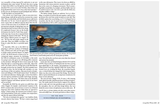
The area south of Teshekpuk Lake is also pockmarked with lakes and wetlands, and it too is filled with birds, many of them nesting. They include rare Yellow-billed Loons; Spectacled Eiders, which are federally listed as threatened; King Eiders; Buffbreasted Sandpipers; Long-tailed Ducks; Red-throated Loons; Semipalmated Sandpipers; Red Phalaropes; Lapland Longspurs; and many more.
For the past three summers, biologists from the Wildlife Conservation Society (WCS), funded in part by the federal government, have been studying the reproductive success of 15 species of nesting shorebirds in the area south of Teshekpuk Lake. The point is to compare the birds’ reproductive success in this undisturbed area with that of the same species in habitat near oil development elsewhere on the coastal plain.
All insectivores, these species can live in close proximity in part by specializing in feeding on different kinds of larval underground insects. “The ones with longer bills are generally after longer-bodied underground arthropod larvae; the ones with shorter bills, the shorter ones,” says ecologist Dave Norton of the University of Alaska at Fairbanks. “The birds might seem to be competing with each other. They’re not. They’re finely adapted.” When the birds do feed on the same prey, he says, they benefit from the arctic’s explosions of insect populations, when so many insects appear at the same time that their predators can’t possibly eat them all at once.
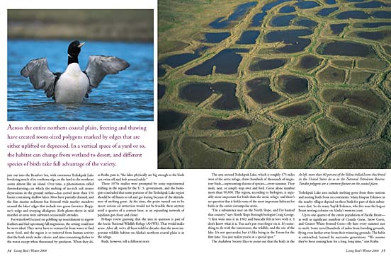
The birds also are exquisitely adapted to microhabitats in what might look to us like an endless carpet of sameness. Over time, in places across the entire northern coastal plain, freezing and thawing have created room-sized polygons marked by edges that are either uplifted or depressed. In a vertical space of just a yard or so, the habitat can change from wetland to desert, and different species of birds take full advantage of the variety.
The WCS scientists painstakingly located nests and kept track of the eggs. “It’s kind of like an Easter egg hunt,” says researcher Joe Liebezeit. If the eggs disappeared, the researchers assumed a predator had dined on them. When chicks hatched, the nest qualified as successful. “What we’re finding so far—and I have to say it’s preliminary—is that nest survivorship does seem higher here than in areas closer to oil development,” says Liebezeit. If the results bear out, it could mean that the predators typically concentrated around oilfields are taking eggs as well as scavenging garbage, or that the business of oil extraction somehow disturbs the nests, or that the habitat south of Teshekpuk Lake is somehow superior. One conclusion Liebezeit can draw for sure, he says, is that “the area around Teshekpuk is an important nursery for birds from around the world.”
Alaska’s northern coastal plain, which covers the entire top of the state, north of the mountains of the Brooks Range, is divided into three sections: two federal pieces sandwiching a state chunk. The middle part holds Prudhoe Bay, where the first successful oil well in Alaska’s far north was drilled about 40 years ago. Ever since then, pipelines and drilling pads have been expanding like spider webs from Prudhoe to the east and west. So far, the growth has almost all been on state land.
The easternmost push stops short of the arctic refuge. On the western side, exploration has just begun to penetrate the other piece of federal land. There, some of the choicest spots for oil development are thought to be in what is known as—take a deep breath—the Teshekpuk Lake Special Area in the Northeast Planning Area of the National Petroleum Reserve-Alaska (NPR-A). At 23.5 million acres, the petroleum reserve is the largest piece of public land in the United States. In the 85 years since it was established, it has occasionally been poked and prodded for oil and gas—both of which have been found—but until recent years, extracting either in large amounts hasn’t been feasible. The cost of transporting the oil has been prohibitive, and the finds were thought to be relatively small.
Also, because oil exploration now takes place only when the tundra is frozen solid enough to withstand the impacts of heavy equipment, explorers are in a race against time when they head out into the dark arctic winter. The farther they go from their usual base of Deadhorse (the community at Prudhoe Bay), the less time they have to work at their destination—and the more money they spend on getting there.
So the notion of drilling for big finds in the NPR–A was more hypothetical than realistic when, in 1976, Congress put the reserve under the direction of the Department of the Interior and told the agency to “take every precaution to avoid unnecessary surface damage and to minimize ecological disturbance throughout the reserve.” The following year, the agency named the area around Teshekpuk Lake an ecological “special area,” along with two others in the petroleum reserve: the Colville River Special Area and the Utukok River Uplands Special Area.
Ever since then, the technology for exploration and drilling has been improving, the cost of oil has been rising. and the infrastructure from Prudhoe Bay has been growing. The federal government has opened some tracts in the reserve for leasing, including in the northeastern part, and a few companies have succeeded in doing some exploration. Last winter, Conoco Phillips even drilled an exploratory well 200 miles to the west of the nearest infrastructure, getting there in part on ice roads and with “rolligons,” vehicles outfitted with giant tires. However, this past fall the company ended up dropping 300,000 acres of its leases in the northeast NPR-A, citing high exploration costs. (It still holds other leases in the area.)
The oil industry has been particularly interested in the northeast corner of the reserve, which also happens to be almost exactly where the most important bird habitat is. Some of the geologic forces that created the habitat also helped shape rocks that could hold a great deal of oil. All across the coastal plain are oil-stained rocks and oil seeps, traces of transformed organic matter that carpeted an ocean bottom during the Mesozoic Age. Although plankton made up the bulk by far of that carbon-rich material, dinosaurs and other animals were also part of the mix.
Eventually, layers of sedimentary rock weighed down the carpet, dropping it deep enough to be cooked into oil and gas by the heat below the earth’s surface. Then, since they were more buoyant than water, the oil and gas began gradually rising up through any openings they encountered. In places they were stopped by rock formations that sealed them in place.
Along much of the coastal plain, when the oil and gas rose out of those hot depths, they migrated toward an uplifted (but still subterranean) area along the coastline. There they encountered an underground ridge called the Barrow Arch, covered with rocks. “The rocks are basically arched over the Barrow Arch,” says geologist Ken Bird of the U.S. Geological Survey. “Some of those layers of rock are impermeable, so they restrict the flow of oil and gas. They basically form a lid.” You couldn’t dream up more perfect conditions for an oil field.
The huge Prudhoe Bay oil discovery in 1968 was right on the Barrow Arch. According to the Bureau of Land Management (BLM), all currently producing oil fields on the North Slope are on or near the Barrow Arch. In fact, virtually all of the oil that has been taken out of the North Slope to date has come from the formation. To the east, the Barrow Arch stops short of the Arctic National Wildlife Refuge. Any oil that might come from the refuge would be from another kind of geologic setting.
To the west, the Barrow Arch runs offshore just north of the Teshekpuk Lake Special Area, and because the ridge gradually rises to the west along its entire length, some speculate that oil has migrated in that direction, says geologist Bird.
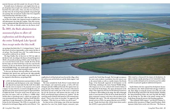
In 2005, the Bush administration announced plans to allow oil exploration and development in the entire Teshekpuk Lake Special Area except under the lake itself. If you didn’t hear the outcry in response to the proposal, you’re in good company. To many observers, it seemed as though the arctic refuge had used up the nation’s attention span for important habitat in Alaska’s far north. “If you live in the Lower 48 and you compare those two names—well, one of them is a ‘wildlife refuge’ and the other is a ‘petroleum reserve’—which one is going to get your environmental juices flowing?” said then–North Slope Borough Mayor George Ahmoagak in a 2004 address to the Alaska Forum for the Environment. The NPR–A is practically in the backyard of several Inupiat villages and the town of Barrow. “Our neighborhood is all that land and water beyond the village, where the caribou roam and the birds nest and the whales migrate,” said Ahmaogak.
The critics included the Pacific Flyway Council, federal and state biologists, and conservation groups, as well as 200 ornithologists and other wildlife professionals who signed a letter opposing the plan. Bruce Babbitt, who as Secretary of the Interior had opened up some nearby parts of the reserve to exploration but not the special area, told reporters that the science in the BLM’s environmental impact statement was “pathetic.” He also noted that much of what he had opened in 1998 remained unexplored. “There’s a slice of pie on your plate,” he suggested to the oil industry. “Why don’t you eat it before you ask for more?”
For those in favor of the leasing, some of the most important opposition has come from Alaska’s Inupiat community, represented by the North Slope Borough. The borough encompasses the state’s entire northern coastal plain, from the western coast to the eastern border, as well as a sizeable chunk of the Brooks Range. It has historically supported oil development on the North Slope, including in the Arctic National Wildlife Refuge. (The Inupiat are not to be confused with Gwich’in Indians to the south of the Brooks Range, who oppose development in the refuge.) That support has been key for the federal government in its attempts to allow drilling in the refuge. But when Ahmoagak spoke to conservationists in 2004, he left no doubt about the Inupiat community’s response at the time to the new plans for the Teshekpuk Lake region. “The risks and potential impacts of industrial activity in NPR–A are greater than they are in ANWR,” he said. “People don’t know that. All they know down south is that ANWR is a giant political football.”
Yup’ik Eskimos also have opposed the development, because their subsistence diet, which includes birds and eggs, would be at risk. Their villages are along the western coast of the state south of the Brooks Range and north of the Aleutian Islands, including the Yukon-Kuskokwim Delta—the state’s big belly that bulges into the Bering Sea. The delta is the primary nesting area for Pacific Brant, hosting 80 percent of the breeding population.
“There definitely will be impacts,” says Myron P. Naneng, Sr., president of the Association of Village Council Presidents, which represents Alaska Natives in the west of the state. “The Brant are very susceptible to being impacted by exploration or any new development that comes around. We know that stress is going to impact their ability to go through the summer without being disturbed. We’ve seen it even in the Y-K Delta, where if they start being disturbed they start to move away or they don’t reproduce.” In short, he says, development around Teshekpuk Lake will have “a really big impact on our people here.”
One concern, says Craig George, is that at some point incremental change could add up and tip the ecosystem into a major shift. “There are thresholds, and I don’t think anyone really knows where they are,” he says. “I am not opposed to careful development. I guess there are different opinions about where the fulcrum is on the teeter-totter. So you default to the precautionary principle of taking large areas out of production until you know what you’re doing. It’s complicated, because I also see the benefits development has had for North Slope people.” At the same time, he says, he is concerned about changing the character of the land. “We were up there doing a fisheries project one August,” he says. “We were the only people camped on the entire lake. There was wildlife everywhere. Just being in a place like that is a powerful experience.”
In September 2006, just as the BLM was preparing to sell leases northeast of Teshekpuk Lake, a federal court order sent the agency back to further analyze potential impacts. In August of 2007, the BLM released a revision of its environmental impact statement for developing the NPR–A’s northeastern corner. In November, as this article was going to press, the agency was still taking public comments on the statement. Although the latest version names the North Slope Borough as a cooperating agency in the draft, Mayor Edward S. Itta made it clear in a 30-page letter to the BLM that the borough’s position has not changed. The BLM included more analysis, he writes, but the borough still concludes—in some cases because of that very analysis—that areas closed to oil exploration and drilling in 1998 should remain closed. “In defense of our traditional subsistence whaling rights, we have been held to the most rigorous standards of scientific study design, reporting, and peer review,” Itta writes. “We believe that no less should be required of agencies and industry operators active in our waters and on our land.”
Presumably the BLM has also gotten an earful from other critics. Imagine, for example, conservationists’ responses to the BLM’s conclusion that “protected areas or reserves are of limited long-term value if the conditions within them are expected to change.” Climate change, the statement notes in detail, is expected to melt permafrost, erode arctic coastlines, raise temperatures, and alter the region’s delicate hydrology.
“We look at it absolutely the opposite,” says Audubon Alaska executive director Stan Senner. “We have a mirror image based on the same information. They want to lay down an oilfield infrastructure with various protective measures in place—and do that in the context of a changing environment. They’re proposing buffers around lakes, for example, and those buffers may not be useful in years to come. Our view is, put aside the whole area, and allow wildlife to adapt.”
The habitat changes already are underway. Sea ice is dwindling— it reached a record low this past summer—and it no longer protects the coast from storms as much as it once did. That probably explains the recent finding, say U.S. Geological Survey researchers, that the rate of coastal erosion north of Teshekpuk Lake doubled from 1985 to 2005 compared with the previous 30 years. Not only has the coast been eaten away, lakes have drained and seawater has intruded.
At the same time, say federal biologists with the USGS and the USFWS, Brant northeast of Teshekpuk Lake have been moving from inland lakes to salt marshes, and populations of Greater White-fronted Geese have exploded. Either the Greater Whitefronted Geese are crowding the Brant, the researchers hypothesize, or altered habitat has changed the birds’ foraging habits. Either way, they write in the journal Polar Biology, “the observed shifts in species distributions are an important consideration for future resource planning.”
The most pervasive change of all, of course, is the warming itself, which ironically could threaten future far-flung oil exploration. The tundra must be frozen hard to support even rolligons and ice roads, and every time greenhouse gases are released into the atmosphere, they not only help change habitat, they may shrink the arctic’s winter oil-exploration season a little more.
All About Birds
is a free resource
Available for everyone,
funded by donors like you
American Kestrel by Blair Dudeck / Macaulay Library